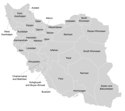
Kerman province
Largest province of Iran, ancient Carmania, rich in history and resources.

Erik Albers · CC BY 4.0
Kerman province is the largest of the 31 provinces of Iran, located in the southeast of the country. Its capital is the city of Kerman. In ancient times it was known as the Achaemenid satrapy of Carmania.
- Capital
- Kerman
- Major language
- Standard Persian (95%)
- Major industry
- Iron mining (Gol Gohar mine)
Lore & Background
In ancient times, Kerman was known as Carmania. An 8th-century text attributed to Movses Khorenatsi places present-day Kerman province in the southern quarter of the Sasanian Empire. The main city from the Sasanian era to the 10th century was Sirjan. Early Muslim geographers considered the area part of the hot climatic zone, with a mountainous interior home to predatory people including the Kufečs. Hamdallah Mustawfi noted that predatory beasts roamed the area, which had undergone forestation. During the Arab conquest of Iran, part of the Iranian population of Kirman was nomadic, including the Baloch who lived in the western mountains. The Arabs also dealt with Baloch who had occupied many parts of Kerman just before the Arabs' arrival. In the 13th century, the province came under the rule of the Qutlugh-Khanids, founded by ethnic Khitans, then under the Mongol Empire, and later under the Timurid empire in the 15th century. The province is prone to natural disasters. A recent flood unearthed the ancient city of Jiroft.
Reader's Guide
Kerman province holds significance as the largest province of Iran, encompassing nearly 11% of the country's land area. Its historical depth stretches back to the Achaemenid satrapy of Carmania, and it played a role in the Sasanian, Arab, Mongol, and Timurid periods. The province's demographic diversity is reflected in its languages—Standard Persian, Garmsiri, Achomi, Turkic dialects, and a Median-type dialect spoken by Jewish and Zoroastrian communities—and in its tribal groups, including Baloch, Jebalbarezi, and Afshar. Economically, Kerman is notable for the Gol Gohar mine, the largest iron mine in Iran, and for the Arg e Jadid specially designated economic zone. Agriculture includes dates, oranges, and pistachios, and historically the province was known for caraway and, in antiquity, for Carmanian wine. Kerman's legacy includes the world's largest adobe structure, Arg-é Bam, and the archaeological site of Jiroft. Its universities, including Shahid Bahonar University of Kerman and Kerman University of Medical Sciences, contribute to education and research.
Did You Know?
- The province was known in ancient times as the Achaemenid satrapy of Carmania.
- The Gol Gohar mine, the largest iron mine in Iran, is located in Kerman province.
Ancient Roots and Medieval Succession of Power
Long before it bore its modern name, this vast southeastern corner of Iran was recorded in antiquity under the name Carmania, serving as an Achaemenid satrapy. An eighth-century text traditionally linked to the Armenian scholar Movses Khorenatsi situates the territory within the southern quarter of the Sasanian Empire, where the principal urban center from the Sasanian period through the tenth century was the city of Sirjan. Early Muslim geographers classified the lowlands as a hot climatic zone while describing the mountainous interior as a refuge for predatory peoples, a group they called the Kufečs or Kofejān. The thirteenth-century writer Hamdallah Mustawfi added that wild beasts still roamed the region, which by his time had experienced some degree of forestation. When Arab armies swept through Iran, they encountered nomadic Baloch communities already settled in the western mountains. Political control shifted repeatedly over the following centuries: ethnic Khitan rulers known as the Qutlugh-Khanids took hold in the thirteenth century, the Mongol Empire absorbed the territory, and by the fifteenth century it fell under Timurid sovereignty.
Mountains, Deserts, and a Landscape Shaped by Water
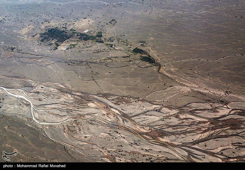
Spanning 183,285 square kilometres—nearly eleven percent of Iran's total land area—Kerman province is the country's largest administrative region. Its terrain is a direct extension of the central Iranian mountain system, which originates in the volcanic folds of Azerbaijan, branches across the central plateau, and ultimately terminates in Baluchestan. The Bashagard and Kuhbonan ranges contain the province's highest summits, including peaks named Toghrol, Aljerd, Palvar, Sirach, Abareq, and Tahrood. Other notable high points stretch from Yazd toward Kerman and Challeh-ye-Jazmoorian, among them Hazaran at 4,501 metres, Kuh-e Shah at 4,402 metres, and the Khabr mountain within Khabr National Park. Despite these dramatic elevations, most of the province is steppe or sandy desert. Scattered oases sustain cultivation of dates, pistachios, and oranges reputed to be the finest in Iran, all irrigated by ancient qanat channels. The region's vulnerability to natural disasters is well documented: a flood in the south exposed the archaeological site of Jiroft, the 2003 earthquake reduced Arg-é Bam—the world's largest adobe structure—to rubble, and a 2005 quake near Zarand claimed hundreds of lives.
A Mosaic of Languages, Tribes, and Settlement Patterns
By the 2016 census, Kerman province was home to roughly 3.16 million people spread across more than 932,000 households, with the capital city of Kerman alone accounting for about 537,000 residents—nearly 29 percent of the province's urban population. Linguistically, the province is overwhelmingly Persian-speaking, with standard Persian used by approximately 95 percent of inhabitants. Local dialects such as Garmsiri and Achomi are close enough to one another to be grouped as a single Kermani variety, which in turn remains mutually intelligible with Standard Persian. Smaller linguistic communities include speakers of Turkic dialects and a Persian Median-type variety maintained by the Jewish and Zoroastrian populations. The tribal landscape is equally diverse: groups of various origins include the Al-e Sa'idi, Khorasani, Balochi, Kuh-e Panji, Qarachi, Ma'sumi-Shul, Bichaqchi, Soleymani, Afshar, Lori, Taheri, Fathi, Narubi, and Jebalbarezi. Among the most prominent nomadic tribal groups are the Baloch, Jebalbarezi, and Afshar, whose mobile lifestyles have shaped the province's pastoral traditions for centuries.
From Caraway Fields to Iron Mines and University Campuses
Kerman's economic identity blends ancient agricultural traditions with heavy industry and modern institutional development. The province's oases have long produced dates, pistachios, and oranges considered the best in Iran, all sustained by qanat irrigation systems that tap underground water channels. As early as 1920, the region was recognized for the exceptional quality of its caraway crop. On the industrial side, the Gol Gohar mine stands as the largest iron mine in the country, anchoring Kerman's role in Iran's mineral extraction sector. The province also hosts Arg e Jadid, a specially designated economic zone intended to attract investment and stimulate growth. In 2014, Kerman was formally assigned to Region 5 within Iran's administrative framework. The province's educational infrastructure includes four notable universities: Shahid Bahonar University of Kerman, Kerman University of Medical Sciences, Sirjan University of Technology, and Jiroft University. Together, these institutions serve a population that grew from about 2.58 million in 2006 to over 3.16 million by 2016, reflecting steady demographic expansion across both urban and rural areas.
Gallery

Frequently Asked Questions
Who is Kerman province?
Kerman province is the biggest of Iran's 31 provincial divisions, sitting in the southeastern part of the country with the city of Kerman serving as its administrative center. It traces its roots back to the Achaemenid-era satrapy known as Carmania.
How does Kerman province's story end?
Rather than a single finale, Kerman's long narrative stretches from Sasanian and Arab conquests through Mongol and Timurid rule into the modern era, where it remains a populated province of over three million residents. Its story is ongoing as a living administrative region of present-day Iran.
More in Provinces Of Iran 1-24
Elsewhere in the Provinces Of Iran universe
Spotted an error? Know more?
This is a living reference — every entry is fact-audited, and reader corrections feed straight into our audit queue. Suggest an edit · See this site's audit record